First published on 09/05/2013, and last updated on 03/05/2018
By: Mina Esteghamat and Fatemeh A. Kamali, CENESTA (Member)
Successful global case studies and examples show how important it is to transfer the power of producing and maintaining information to reach appropriate decisions. During the last year a number of activities have been carried out to document information by/with several indigenous peoples and local communities in Iran, with the help of CENESTA staff and the support of UNDP GEF SGP, to prepare a documentary map of tribal territories and ICCAs.
With the aim of community-based development projects based on community participation and engagement and as a new complementary step to recognize and introduce the customary territories of nomads considering their FPIC, CENESTA is now making concrete agreements to move this practice forward.
A systematic training programme on participatory GIS techniques for representatives of a dozen tribal confederacies and independent tribes and core CENESTA staff is being planned with the support of national and international partners. In preparation for that, three practical experiences were carried out with the Abolhassani tribal confederacy, the Heybatlou sub-tribe and the Farsimadan Tribe, to determine the geographical coordinates of the borders of their territories. The objective was to find a better model of development for those communities, document their knowledge and demarcate their ancestral territories.
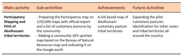
Participatory Mapping and GIS of Abolhassani Tribal Territory
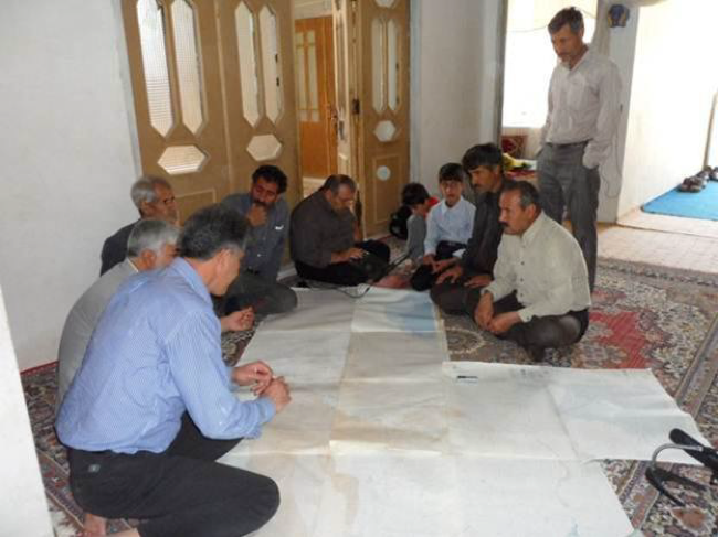
A pilot/demonstration training activity in the Abolhassani Tribe in the Khartouran region east of Tehran, on the border of the provinces of Semnan, Khorasan and Yazd, was framed within a two days of practical training in participatory mapping and PGIS. The list of customary pastures were prepared by the community and, based on that, a participatory map was prepared on an existing map at a scale of 1/50,000 available from the Bureau of Natural Resources of Semnan province. Here is the schematic participatory map drawn by the local community.
The next step was to superimpose this schematic map of the tribal territory onto a GPS-supported one. Meanwhile, with the help of the team from CENESTA and an expert from the Bureau of Natural Resources, one of the local people from Abolhassani tribe was trained to do the GIS mapping of the whole area. He used a motorcycle to get around the boundary of their tribal territory and recorded a number of coordinates which was then sent to the Bureau of Natural Resources to produce a digital GIS map of the area.
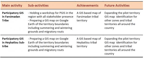
PGIS in Heybatlou Sub-tribe, Shesh Boluki Tribe, Qashqaee Tribal Confederacy
Following the previous activity and achieved experiences in Abolhassani and in line with the general goals of ICCA recognition, preparing an integrated map of ICCAs identified and under exploration and expanding this participatory approach into the whole ICCAs in the region, a team from CENESTA was sent to the tribal territory of Heybatlou Sub-tribe in South-West of Iran.
 According to the earlier arrangements, all the members of Sustainable Livelihood Fund of the mentioned community gathered in a determined place in their wintering grounds. After a short description about the aims, expected results and the methodology of the process, the community representatives (about 12 persons) began discussing and exchanging ideas to come to a consensus regarding their territory’s boundaries. Then, with the facilitation of CENESTA experts and using the Google Earth platform available on line, they demarcated the wintering and summering ground boundaries and defined the migratory routes, using as benchmarks some places they know well along or nearby the boundaries of their migratory routes. They also identified areas that were seized illegally by the government and outsiders, despite the protective policies that have been stressed, in particular during in recent years.
The PGIS process combined with the Google Earth platform and software brought excellent results. The participants explained enthusiastically the procedure to each other and admired it. The advantages of this method comparing to 1/50,000 maps and GPS was the high accuracy that made them capable to understand the terrains in a 3D view, while they were sitting at home. They could see the roads, rivers, agricultural fields, mountains and hills, lakes, villages, cities and even vegetation cover which made them exited and motivated. In addition, this is a time and money saving approach, instead of going around the territory and marking the points by GPS besides demarcating the territory on the 1/50,000 maps with the help of an expert from the Bureau of Natural Resources.
After all the geographical coordinates of the territory have to be transferred to ArcGIS software matching with information layers. The next step would be to define all the territories on the digital map of the country and to investigate the overlaps with other boundaries and margins, for instance of protected areas. Based on such findings, some alternative suitable migratory routes could be found and secured in place of the ones that were made impossible because of illegal seizures.
Based on the outcomes and assessments of these explorations we have seen how wisely these routes were defined, in terms of length and suitability, by the indigenous people on the basis of their precious knowledge and experiences during thousands of years! Results from this pilot activity have been very encouraging for some other surrounding communities as they asked us to be accompanied through the same process for their territories to be demarcated and registered. In particular this platform would enable the nomads to define and document their claim of their territory that subsequently will enable them to participate in assessment, analysis, planning, decision making and management of their territory.
Participatory GIS in Farsimadan Tribe, Qashqaee Tribal Confederacy
 We started this activity on the basis of earlier and similar practices in the realm of GIS activities and workshops. The PGIS procedure was similar to what have been done in Heybatlou Sub-tribe territory. We had available a participatory map prepared in an earlier workshop with the presence of nearly all the stakeholders, including the council of elders, members of sustainable livelihood funds, experts and CENESTA facilitators. The existing map was considered as a base map for the current action and gave the possibility of comparing and improving the results.
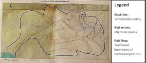
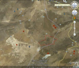
With respect to the previous activity in Heybatlou Sub-tribe, however, this action engaged a larger group of people, as the Farsimadan tribe involves 24 sub-tribes. This was the cause of some anticipated conflicts among the community representatives, who took a longer time to come to an agreed outcome. Because of the mentioned conflicts, there was more than one migratory route defined by the participants, a fact that required the council of elders to be involved and finalize the routes. This was an important new experience for the Cenesta PGIS facilitators’ team and the results of this can be applied to other, similarly large communities. The following map shows the tribal territory of Farsimadan extracted from Google Earth and overlapped with the country map.
All the mentioned efforts towards demarcating the boundaries of the migratory routes and defining the ICCAs are towards the end goal of an ICCA Recognition Plan, which would involve preparing an integrated map of ICCAs superimposed upon national, regional and global maps. On the basis of such maps, conflicts could be resolved, participatory management could be carried out and the rights of indigenous people over their territories could be properly secured.